Κατέβασμα παρουσίασης
Η παρουσίαση φορτώνεται. Παρακαλείστε να περιμένετε

1
Στραγγίσεις και Επιπτώσεις στο Περιβάλλον Χ.Ευαγγελίδης

2
Στράγγιση είναι η φυσική ή τεχνητή απομάκρυνση του πλεονάζοντας επιφανειακού ή υπόγειου νερού από μια συγκεκριμένη περιοχή. Επίσης επιτυγχάνεται με αυτό τον τρόπο η βελτίωση των υδρολογικών συνθηκών

3
Drainage is land and water management through the processes of removing excess surface water and managing shallow water tables—by retaining and removing water—to achieve an optimal mix of economic and social benefits while safeguarding key ecological functions

4
ΑΝΑΓΚΗ ΓΙΑ ΣΤΡΑΓΓΙΣΗ Θεμελιώσεις Το φρεαστικό επίπεδο πρέπει να υποβιβαστεί ικανά ώστε να διευκολύνει τις εργασίες. Πιθανή ανάγκη μόνιμης στράγγισης για την αποφυγή διάβρωσης των θεμελίων Αναχώματα και πλαγιές Το νερό πρέπει να αποστραγγιστεί για προστασία κατολισθήσεων. Υψηλή πίεση του νερού στους πόρων μειώνουν την αντοχή του εδάφους

5
ΑΝΑΓΚΗ ΓΙΑ ΣΤΡΑΓΓΙΣΗ Θεμελιώσεις Το φρεαστικό επίπεδο πρέπει να υποβιβαστεί ικανά ώστε να διευκολύνει τις εργασίες. Πιθανή ανάγκη μόνιμης στράγγισης για την αποφυγή διάβρωσης των θεμελίων Αναχώματα και πλαγιές Το νερό πρέπει να αποστραγγιστεί για προστασία κατολισθήσεων. Υψηλή πίεση του νερού στους πόρων μειώνουν την αντοχή του εδάφους

7
Minnesota New Orleans

8
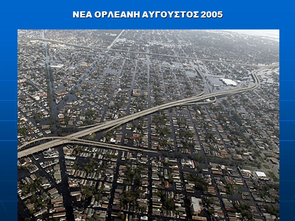
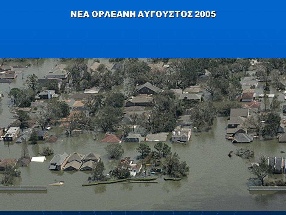
ΝΕΑ ΟΡΛΕΑΝΗ 49% είναι κάτω από την επιφάνεια της θάλασσας Με τις πιο πυκνοκατοικημένες περιοχές γενικά, πάνω από την επιφάνεια της θάλασσας το μέσο υψόμετρο της πόλης 30 έως 60 cm κάτω από την επιφάνεια της θάλασσας με περιοχές υψόμετρου 5 m και άλλες με - 3m

9
The earliest archaeological record of an advanced system of drainage comes from the Indus Valley Civilization from around 3100 BC in what is now Pakistan and North India. The ancient Indus systems of sewerage and drainage that were developed and used in cities throughout the civilization were far more advanced than any found in contemporary urban sites in the Middle East and even more efficient than those in some areas of modern Pakistan and India today. All houses in the major cities of Harappa and Mohenjo-daro had access to water and drainage facilities. Waste water was directed to covered drains, which lined the major streets.Indus Valley Civilization3100 BC PakistanNorth IndiasewerageMiddle EastHarappaMohenjo-daro water

11
The largest project of this type in the world has been in process for centuries in the Netherlands. The area between Amsterdam, Haarlem and Leiden was, in prehistoric times swampland and small lakes. Turf cutting (Peat mining), subsidence and shoreline erosion gradually caused the formation of one large lake, the Haarlemmermeer, or lake of Haarlem. The invention of wind powered pumping engines in the 15th century permitted drainage of some of the marginal land, but the final drainage of the lake had to await the design of large, steam powered pumps and agreements between regional authorities. The elimination of the lake occurred between 1849 and 1852, creating thousands of km² of new land.NetherlandsAmsterdamHaarlemLeiden prehistoricPeatminingsubsidence erosionHaarlemmermeerwindpumping 15th centurysteam powered1849 1852km
, subsidence and shoreline erosion gradually caused the formation of one large lake, the Haarlemmermeer, or lake of Haarlem. The invention of wind powered pumping engines in the 15th century permitted drainage of some of the marginal land, but the final drainage of the lake had to await the design of large, steam powered pumps and agreements between regional authorities. The elimination of the lake occurred between 1849 and 1852, creating thousands of km² of new land.NetherlandsAmsterdamHaarlemLeiden prehistoricPeatminingsubsidence erosionHaarlemmermeerwindpumping 15th centurysteam powered km.")
12
Small differences in elevation distinguish the "Low Netherland" in the north and west at less than one meter above sea level, from the more elevated "High Netherlands" in the south and east, which reaches an altitude of 321 m in the southeast. Approximately a third of the entire country lies below sea level at high tide. Another 25 percent is so low-lying that it would be subject to inundation if it were not for the surrounding dunes and dikes and the regular pumping of excess water. An area surrounded by dikes where the water table can be controlled is called a polder. The lowest point is 6.7 m below mean sea level, immediately to the northeast of Rotterdam. The Wadden Sea is a world- renowned bird sanctuary.

13
Drainage Three of Europe's most important waterways – the Maas (Meuse), Rijn (Rhine) and Schelde (Scheldt) – enter the sea through a common delta in the southwest. Here, the Rhine divides into three major distributaries: the Waal, Lek, and IJssel. A number of small lakes dot the polder lands, filling hollows from which peat was once removed for fuel. A network of canals and dikes crisscrosses the flat polder lands to provide an artificial drainage system that keeps the land dry. In ancient times floodwaters regularly invaded the lowlands, forcing people to build their homes on artificial mounds called terpen. During the Middle Ages, dikes were built, enclosing lower-lying polders in which groundwater levels could be controlled. In the 16th and 17th centuries windmills were used to pump excess water from the polders, and many small western lakes were transformed into dry land. Steam, and later diesel and electric, pumps made possible the reclamation of larger areas. In 1853 the Haarlemmermeer polder was drained to create 162 square kilometers of new land. The Zuiderzee Plan, begun in 1920 with a dike that closed off the former Zuiderzee, provides 2,050 square km of new land in five polders – Wieringermeer (completed in 1930), the Northeast (1945), East Flevoland (1957),
, the Northeast (1945), East Flevoland (1957),.")
14
South Flevoland (1968), and Markerwaard (begun 1978). The freshwater IJsselmeer was meanwhile also formed and a new province, Flevoland (consisting of east and south Flevoland together with the northeastern polder), was created in 1986. The same year marked the completion of the Delta Plan, a massive flood-control project begun in 1958 to protect the province of Zeeland from the tidal waves, which has frequently inundated it. To achieve this, a series of dams and barriers were built, closing off from the sea the estuaries of the Rhine, Meuse, and Eastern Scheldt rivers, and creating the freshwater lakes Haringvliet and Grevelingen. Surplus water from the rivers exits via the Nieuwe Waterweg (New Waterway) and through sluices in the Haringvliet dam. Only the Western Scheldt and the New Waterway remain open for access to Rotterdam and Antwerp in Belgium.
, was created in The same year marked the completion of the Delta Plan, a massive flood-control project begun in 1958 to protect the province of Zeeland from the tidal waves, which has frequently inundated it. To achieve this, a series of dams and barriers were built, closing off from the sea the estuaries of the Rhine, Meuse, and Eastern Scheldt rivers, and creating the freshwater lakes Haringvliet and Grevelingen. Surplus water from the rivers exits via the Nieuwe Waterweg (New Waterway) and through sluices in the Haringvliet dam. Only the Western Scheldt and the New Waterway remain open for access to Rotterdam and Antwerp in Belgium..")
15
Minnesota New Orleans

16
ΝΕΑ ΟΡΛΕΑΝΗ ΑΥΓΟΥΣΤΟΣ 2005

19
Minnesota New Orleans

20
Minnesota New Orleans

22
The drainage paradox is this. Improvement of drainage, on the face of it, could be an important instrument for achieving sustainable human development, while in reality it has almost disappeared from international water discourse as a theme and a concern. Also, investment in drainage by governments and in the lending portfolios of financial institutions is decreasing. To resolve this paradox, drainage has to reclaim its rightful position as an indispensable component of the management of land and water, not from an agricultural sector perspective, but from an integrated perspective.

23
rainage is an inherent part of the hydrological cycle—a necessary function of a river basin or other hydrological units. Drainage is a natural process that human beings adapt for their own purposes by redirecting water in space and time and manipulating water levels. In this process, they make use of the natural properties of topography, soil, and hydrogeology and of technologies and other physical and management interventions.

24
Agricultural production. In Egypt, the annual net farm income of the traditional farm increased by US$375/ha to US$200/ha, depending on the initial level of salinity before providing subsurface drainage. With total construction costs of US$750/ha and maintenance costs of US$10/ha/year, the payback period is only three to four years. In Pakistan, crop yields increased between 27 percent and 150 percent in the Mardan project area. In Mexico, economic rates of return of the subprojects in the Program for Integrated Rural Development in the Tropical Wetlands (PRODERITH), based only on the changes in agricultural yields, varied between 14.7 percent and 21.5 percent. Public health, drinking water supply, and sanitation. Improved drainage conditions in the Netherlands helped control endemic rheumatism in rural areas. Drainage in rural areas in Egypt and Pakistan brought down the incidence of killer diseases such as malaria and schistosomiasis (bilharzias). A low water table is necessary for low-cost latrines in rural settlements. Lowering water tables in the Drainage IV project area near Faisalabad, Pakistan, allowed a thin lens of fresh water to develop for domestic water supply on top of the saline groundwater.
, based only on the changes in agricultural yields, varied between 14.7 percent and 21.5 percent. Public health, drinking water supply, and sanitation. Improved drainage conditions in the Netherlands helped control endemic rheumatism in rural areas. Drainage in rural areas in Egypt and Pakistan brought down the incidence of killer diseases such as malaria and schistosomiasis (bilharzias). A low water table is necessary for low-cost latrines in rural settlements. Lowering water tables in the Drainage IV project area near Faisalabad, Pakistan, allowed a thin lens of fresh water to develop for domestic water supply on top of the saline groundwater..")
25
Buildings and rural infrastructure. A high water table is responsible for short service life and damage to buildings, particularly low-income housing in large parts of rural Pakistan, India, Egypt, and Mexico. Conversely, improved drainage increases the value of land, as in the humid part of Mexico under the PRODERITH program from US$7,000 to US$200,000/ha. Floods and flood control. A sufficiently lowered water table before the rainy season reduces runoff and moderates the peak flood wave. However, uncontrolled deep drainage canals may quickly transport flooding to areas downstream. Construction of embankments along main rivers in Bangladesh has had mixed impacts on soil productivity, living conditions, fish production, sediment deposition, soil fertility, water storage, and navigation. Environmental functions. On the negative side, drainage mobilizes salts and agricultural chemicals and spreads pollution caused by untreated domestic and industrial wastewater dumped into open drains in many countries. In the humid tropic lowlands of Indonesia, drainage of acid sulphate soils has caused serious damage to the valuable coastal aquatic life. In other cases, drainage has created wildlife refuge areas of great biodiversity value such as around Lake Sarykamysh near the Aral Sea.

Παρόμοιες παρουσιάσεις


 ωφελέειν ή μη βλάπτειν ωφελέειν = θεραπευτική παρέμβαση μη βλάπτειν = ασφάλεια ασθενών.>")


